 Filter: Categories of Wisconsin Historical Images
Filter: FORMAT_DIMENSIONS of 23 x 18 inches
Filter: Categories of Wisconsin Historical Images
Filter: FORMAT_DIMENSIONS of 23 x 18 inches
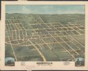
| Date: | 1875 |
|---|---|
| Description: | Bird's-eye map of Dodgeville, looking east, with insets of the high school and county courthouse. |
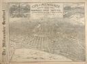
| Date: | 08 28 1889 |
|---|---|
| Description: | Bird's-eye view of Milwaukee, drawn from sketches and photographs for the "Milwaukee Daily Sentinel," with insets of Schlitz Park and the Pabst Brewing Com... |

| Date: | |
|---|---|
| Description: | Map of Baraboo and its surroundings, showing the ancient mound city, the water power, and thoroughfares, drawn by William H. Canfield. Canfield includes sk... |
If you didn't find the material you searched for, our Library Reference Staff can help.
Call our reference desk at 608-264-6535 or email us at: